Brooklyn Waterfront Bike Ride: Brooklyn Bridge Park to Williamsburg
How long is the Brooklyn waterfront bike ride from Brooklyn Bridge Park to Williamsburg?
It's roughly 8 to 10 km (5 to 6 miles) one way, depending on your exact start and end points, and takes about 1 to 1.5 hours at a relaxed pace with stops. The route is not one continuous protected bike path; a few short sections run in shared traffic.
The route, in plain terms
Brooklyn’s waterfront gives cyclists something rare in New York: several kilometres of riding with open water on one side and the Manhattan skyline across the river on the other, mostly flat, mostly free of the stop-and-start traffic that makes cycling in the boroughs’ interior streets more stressful. The classic version of this ride starts somewhere around Brooklyn Bridge Park — often near the Brooklyn Bridge itself or a little south near Atlantic Avenue — runs north through DUMBO, and continues into Williamsburg, finishing at one of that neighbourhood’s waterfront parks.
Total distance runs roughly 8 to 10 km (about 5 to 6 miles) one way, depending on the exact start and finish points chosen. At a relaxed, sightseeing pace — stopping for photos of the bridges, pausing in DUMBO, slowing through the crowds near the Domino Park area — the ride itself takes about an hour to an hour and a half. That figure covers riding time only; anyone planning to get off the bike and explore Brooklyn Bridge Park’s lawns and piers, or wander DUMBO’s cobblestone blocks, should add extra time on top.
This is a linear, point-to-point ride rather than a loop. Riders either arrange to return the way they came, ride a different route back through Brooklyn’s interior streets, or — most simply — pick up and drop off a shared bike at each end, which is where Citi Bike becomes the practical choice.
What you’ll pass along the way
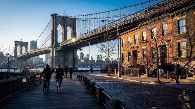
Starting in Brooklyn Bridge Park, the route runs beneath the Brooklyn and Manhattan Bridges, through a stretch of reclaimed industrial waterfront turned into lawns, piers, a carousel, and sport courts, all facing directly across the East River at Lower Manhattan. This is one of the best places in the city for a photo with the skyline, and it gets busy on weekends because of it.
Continuing north into DUMBO, the path passes the neighbourhood’s cobblestone streets and its famous framed view of the Manhattan Bridge between old warehouse buildings — now converted into apartments, galleries and shops. DUMBO is compact and popular, so expect to slow down here regardless of the time of day.
From DUMBO, the ride continues along the Brooklyn waterfront through the Navy Yard area and into Williamsburg, where riders typically finish at one of the neighbourhood’s waterfront parks — Domino Park, built on the site of a former sugar refinery, or the somewhat quieter East River State Park a little further north, both offering more skyline views and green space to rest before heading back or continuing on into Williamsburg’s streets.
Distance and time at a glance
| Segment | Approximate distance | Approximate time (moderate pace) |
|---|---|---|
| Brooklyn Bridge Park to DUMBO | 1-2 km | 5-15 minutes |
| DUMBO to Brooklyn Navy Yard area | 2-3 km | 10-20 minutes |
| Navy Yard area to Williamsburg waterfront | 3-4 km | 20-30 minutes |
| Full one-way ride (varies by exact endpoints) | 8-10 km | 60-90 minutes |
These figures assume a casual pace with occasional stops, not a sustained sporting pace. A fit cyclist riding without stopping can cover the same distance considerably faster; a family group stopping often for photos should budget more time, not less.
Renting a bike: Citi Bike versus a bike shop
New York’s bike-share system, Citi Bike, is the most convenient option for a one-way ride like this, since docking stations are common along the waterfront in Brooklyn Bridge Park, DUMBO and Williamsburg, meaning there’s no need to double back to a single rental point.
Citi Bike pricing works two ways: a single-ride unlock that includes a set initial period (commonly 30 minutes) with additional charges if you keep the bike longer, or a day pass giving unlimited rides of a set length within a 24-hour window, priced at roughly $20-22 as of 2026. The day pass suits this ride well, since it allows docking and re-undocking a bike at stops along the way without extra per-ride charges, as long as each individual ride stays under the included time limit.
A specialty bike shop rental, by contrast, charges by the hour or by the day for a single bike kept the whole time, with no docking-station juggling and generally a better-quality bike — useful for riders who want to wander off the planned route, ride at their own pace for several hours, or aren’t comfortable relying on finding an open dock at the finish. The trade-off is a meaningfully higher hourly cost than Citi Bike, and the need to return to the shop rather than finishing wherever is convenient.
| Rental type | Typical cost | Best for |
|---|---|---|
| Citi Bike single ride | A few dollars for the unlock plus first ride period, more for overtime | A quick one-way trip with a firm finish point |
| Citi Bike day pass | Roughly $20-22 for 24 hours | Point-to-point riding with several stops along the way |
| Bike shop rental | Priced by the hour or day, notably more per hour than Citi Bike | Longer rides, detours off-route, no need to dock at a station |
Where the path is protected, and where it isn’t
It’s tempting to picture this ride as one uninterrupted, car-free bike path hugging the water from end to end. That isn’t quite accurate, and it’s worth knowing before setting out. Long stretches through Brooklyn Bridge Park and much of the Williamsburg waterfront do run on marked, physically separated bike lanes or shared paths well away from vehicle traffic. But the route is not continuous in that form the entire way: a handful of short sections — certain street crossings, gaps where the greenway hasn’t been fully built out, and stretches near the Navy Yard area — require merging into a regular street lane alongside cars, at least for a block or two.
None of this makes the ride unsafe for a reasonably alert cyclist who’s used to city streets, but it does mean staying attentive at intersections and not assuming the path will stay separated for the full 8 to 10 km. Riders who are nervous about any shared-traffic riding should look at a guided tour instead, or stick to the sections of the route that run through park land only, turning around at the point where a shared-traffic stretch begins.
Wind, weather and the exposed waterfront
Because the entire ride runs along open water, with the East River on one side and, for stretches, very little in the way of buildings or tree cover to block the wind, weather affects this route more than it would an equivalent ride through Brooklyn’s interior streets. A stiff headwind off the harbor can slow a return trip noticeably, and gusty days make riding near the water’s edge less pleasant than the map distance alone suggests. Rain also has nowhere to drain quickly along some sections of waterfront path.
Checking wind speed and direction alongside the general rain forecast before setting out is worth the extra minute, particularly for anyone riding round-trip rather than dropping the bike at a dock in Williamsburg. A ride that looks easy on a still day can turn into real effort against a 25 km/h headwind coming off the water.
Doing it guided versus self-guided
Riding this route independently, on a rented Citi Bike or shop bike, costs less and allows a personal pace, stopping wherever looks interesting and skipping anything that doesn’t. It requires a basic comfort with navigating on the fly, since waterfront bike paths in New York aren’t always signed as clearly as a first-time visitor might expect.
For visitors who’d rather have someone else handle the route and the storytelling, Brooklyn’s neighbourhoods along this waterfront corridor are also covered on foot by several guided options that hit the same ground at walking pace: the NYC: Brooklyn Bridge DUMBO Walking Tour covers the Brooklyn Bridge Park and DUMBO stretch in detail, while the New York: Best of Brooklyn 2 Hour Walking Tour gives a broader introduction to the borough for those combining the ride with other sightseeing.
Riders wanting more context on Brooklyn’s industrial and creative history along this same waterfront might also look at the Made in Brooklyn Tour, and those curious about the Navy Yard area the route skirts can consider the Brooklyn: Navy Yard Tour, which goes inside a part of the waterfront the bike route only passes alongside.
Practical tips for the ride
Start early or mid-morning on weekends to beat the worst of the Brooklyn Bridge Park and DUMBO crowds, both on the path and on foot — this stretch is popular with joggers, pedestrians and other cyclists all sharing a fairly narrow corridor. Carry water, since shaded rest points are limited along the more exposed sections near the water. Lock any personally-owned bike properly if stopping to explore on foot; Citi Bikes simply dock at any station along the way, which removes that concern entirely. Wear layers if riding in cooler months, since wind chill along open water runs noticeably colder than the ambient street temperature a few blocks inland.
Anyone continuing past Williamsburg or starting further south should factor in the extra distance and time separately — the 8 to 10 km figure describes the core Brooklyn Bridge Park to Williamsburg stretch, not an extended ride into Coney Island or further along the Brooklyn waterfront.
For a broader sense of how a waterfront ride fits into a wider day or two in the borough, see the Brooklyn Bridge DUMBO walking tour guide and the DUMBO and Brooklyn Heights Promenade guide for what to see on foot at either end, and the Williamsburg food tour guide for where to refuel after finishing the ride.
Other ways to see the same stretch of waterfront
Cycling isn’t the only way to cover this ground, and pairing the ride with a slower pass on foot fills in details that go by too fast from a saddle. The Brooklyn Bridge walking tour guide covers the crossing itself for anyone who wants to walk it separately rather than just ride past the base, and the DUMBO Brooklyn Bridge photo shoot guide is worth a look before setting out, since the best angles on that famous Manhattan Bridge view are easy to miss at bike speed.
At the Williamsburg end, the Williamsburg walking tour guide and the Williamsburg nightlife and bar crawl guide both pick up where the ride leaves off, for anyone parking the bike at a dock and continuing on foot into the evening. Riders more interested in murals and street art than bars can also check the Williamsburg Street Art & Nightlife Tour, which covers ground just inland from the waterfront parks where this ride finishes.
Anyone comparing this route to biking options elsewhere in the city should note that Manhattan has its own riverside path, covered in the Hudson River Greenway bike rental guide, and Central Park offers a shorter, car-free loop described in the Central Park guided bike tour guide — a gentler option for riders who find the open-water exposure of the Brooklyn waterfront more than they bargained for.
Fitting this ride into a longer Brooklyn day
A single Brooklyn Bridge Park to Williamsburg ride fills a morning or an afternoon, not a full day, which leaves room to combine it with other Brooklyn ground. The two-day Manhattan and Brooklyn itinerary and the five-day, five-neighbourhoods itinerary both place a Brooklyn waterfront stretch alongside other stops in the borough, and the realistic one-day Brooklyn itinerary on the blog is a useful gut check on how much ground is actually reasonable to cover in a single visit once this ride is factored in.
Riders who’d rather return to Manhattan by subway than backtrack by bike can dock a Citi Bike in Williamsburg and cross back under the river; the NYC subway OMNY and MetroCard guide covers how fares and cards work for that last leg.
Brooklyn waterfront bike ride: frequently asked questions
How long is the ride from Brooklyn Bridge Park to Williamsburg?
Roughly 8 to 10 km (5 to 6 miles) one way, depending on exactly where you start under the Brooklyn Bridge and where you finish in Williamsburg. At a modest, sightseeing pace with photo stops, plan on 1 to 1.5 hours of riding time, not counting time spent off the bike in DUMBO or Brooklyn Bridge Park.
Is the bike path continuous the whole way?
No. Marked, physically separated bike lanes cover most of the route through Brooklyn Bridge Park, DUMBO and into the Williamsburg waterfront, but a handful of short segments — street crossings, gaps near construction, and stretches where the greenway hasn’t been extended — require riding in a regular traffic lane alongside cars. Nobody should promise an uninterrupted, fully protected lane for the entire ride, because that’s not currently accurate.
How much does a Citi Bike cost for this ride?
A single-ride Citi Bike unlock plus the first 30 minutes runs a few dollars, with extra charges per additional 15 to 30 minutes on a classic bike; a day pass giving unlimited 30-minute rides for 24 hours typically costs around $20-22. Both are cheaper per hour than a specialty bike shop rental, which charges by the hour or by the day for a bike you keep for a longer, uninterrupted block of time.
Should I use Citi Bike or rent from a bike shop?
Citi Bike is the cheaper, more flexible option for a single point-to-point ride like this one, since you dock the bike near your finish and don’t have to loop back. A bike shop rental costs more per hour but gives you a better bike, no docking-station hunt, and no time-limit surcharges, which suits people who want to wander off-route or ride for several hours.
Do I need to check the weather before going?
Yes. The route runs directly along open water for most of its length, with no buildings or trees to block wind, so headwinds, gusts off the harbor, and exposed sun or rain all hit harder here than on an inland street. Check wind speed as well as the rain forecast, and expect a stiffer ride on a windy day, especially heading north into a headwind.
Where does the ride start and end?
A typical start is Brooklyn Bridge Park near the Brooklyn Bridge or Fulton Ferry Landing in DUMBO; a typical end is somewhere in Williamsburg’s waterfront parks, such as Domino Park or East River State Park. Many riders reverse the route or start further south, near Atlantic Avenue, which adds distance.
Can I combine this ride with the Brooklyn Bridge or DUMBO sightseeing?
Yes, and most people do. DUMBO’s cobblestone streets and the view of Manhattan Bridge framed between buildings sit right on the route, as does the base of the Brooklyn Bridge. Plan extra time off the bike here, since this stretch is the most photographed and most crowded part of the ride.
Is this ride suitable for beginners or families with kids?
Confident casual riders and older kids comfortable on a bike in a city setting can manage it, since most of the route is flat and separated from traffic. Very young children or nervous beginners should be aware of the shared-traffic sections and the crowds in Brooklyn Bridge Park and DUMBO, where pedestrians, joggers and other cyclists all compete for the same narrow lane.
Brooklyn Tours
Verified deep-linked GetYourGuide tours. Book through these links and we earn a small commission at no cost to you.
GetYourGuide does not provide a product photo for this activity — the image shows the meeting point, photographed by us.